Welcome to Partnership Initiatives of United Nations Department of Operational Support Home · LOGIN · JOIN Overview About Us Governance Structure Members CI Contact Us What We Do DWG 1: Hybrid GIS Platform DWG 2: Capacity Building DWG 5: GEOAI & Analytics DWG 6: OpenDroneMap & 3D DWG 7: Smart Maps Best Practices Resources SW Downloads Source Codes Documents News and Media News and Media Meeting Schedule News Videos Photos Call for Participation Members Login Join Privacy Notice Terms of Use Copyright Mypage HOME · LOGIN · JOIN Home Overview Overview About Us Governance Structure Members CI Contact Us What We Do What We Do DWG 1: Hybrid GIS Platform DWG 2: Capacity Building DWG 5: GEOAI & Analytics DWG 6: OpenDroneMap & 3D DWG 7: Smart Maps Best Practices Resources Resources SW Downloads Source Codes Documents News and Media News and Media News and Media Meeting Schedule News Videos Photos Call for Participation Members Login Join Privacy Terms Copyright Mypage
Welcome to Partnership Initiatives of United Nations Department of Operational Support Home · LOGIN · JOIN Overview About Us Governance Structure Members CI Contact Us What We Do DWG 1: Hybrid GIS Platform DWG 2: Capacity Building DWG 5: GEOAI & Analytics DWG 6: OpenDroneMap & 3D DWG 7: Smart Maps Best Practices Resources SW Downloads Source Codes Documents News and Media News and Media Meeting Schedule News Videos Photos Call for Participation Members Login Join Privacy Notice Terms of Use Copyright Mypage HOME · LOGIN · JOIN Home Overview Overview About Us Governance Structure Members CI Contact Us What We Do What We Do DWG 1: Hybrid GIS Platform DWG 2: Capacity Building DWG 5: GEOAI & Analytics DWG 6: OpenDroneMap & 3D DWG 7: Smart Maps Best Practices Resources Resources SW Downloads Source Codes Documents News and Media News and Media News and Media Meeting Schedule News Videos Photos Call for Participation Members Login Join Privacy Terms Copyright Mypage
Home · LOGIN · JOIN Overview About Us Governance Structure Members CI Contact Us What We Do DWG 1: Hybrid GIS Platform DWG 2: Capacity Building DWG 5: GEOAI & Analytics DWG 6: OpenDroneMap & 3D DWG 7: Smart Maps Best Practices Resources SW Downloads Source Codes Documents News and Media News and Media Meeting Schedule News Videos Photos Call for Participation Members Login Join Privacy Notice Terms of Use Copyright Mypage
Overview About Us Governance Structure Members CI Contact Us What We Do DWG 1: Hybrid GIS Platform DWG 2: Capacity Building DWG 5: GEOAI & Analytics DWG 6: OpenDroneMap & 3D DWG 7: Smart Maps Best Practices Resources SW Downloads Source Codes Documents News and Media News and Media Meeting Schedule News Videos Photos Call for Participation Members Login Join Privacy Notice Terms of Use Copyright Mypage
Overview About Us Governance Structure Members CI Contact Us What We Do DWG 1: Hybrid GIS Platform DWG 2: Capacity Building DWG 5: GEOAI & Analytics DWG 6: OpenDroneMap & 3D DWG 7: Smart Maps Best Practices Resources SW Downloads Source Codes Documents News and Media News and Media Meeting Schedule News Videos Photos Call for Participation Members Login Join Privacy Notice Terms of Use Copyright Mypage
HOME · LOGIN · JOIN Home Overview Overview About Us Governance Structure Members CI Contact Us What We Do What We Do DWG 1: Hybrid GIS Platform DWG 2: Capacity Building DWG 5: GEOAI & Analytics DWG 6: OpenDroneMap & 3D DWG 7: Smart Maps Best Practices Resources Resources SW Downloads Source Codes Documents News and Media News and Media News and Media Meeting Schedule News Videos Photos Call for Participation Members Login Join Privacy Terms Copyright Mypage
Home Overview Overview About Us Governance Structure Members CI Contact Us What We Do What We Do DWG 1: Hybrid GIS Platform DWG 2: Capacity Building DWG 5: GEOAI & Analytics DWG 6: OpenDroneMap & 3D DWG 7: Smart Maps Best Practices Resources Resources SW Downloads Source Codes Documents News and Media News and Media News and Media Meeting Schedule News Videos Photos Call for Participation Members Login Join Privacy Terms Copyright Mypage
Home Overview Overview About Us Governance Structure Members CI Contact Us What We Do What We Do DWG 1: Hybrid GIS Platform DWG 2: Capacity Building DWG 5: GEOAI & Analytics DWG 6: OpenDroneMap & 3D DWG 7: Smart Maps Best Practices Resources Resources SW Downloads Source Codes Documents News and Media News and Media News and Media Meeting Schedule News Videos Photos Call for Participation Members Login Join Privacy Terms Copyright Mypage
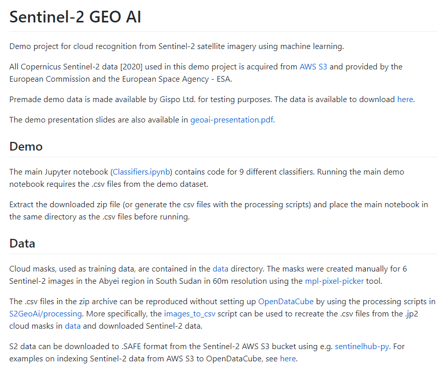
Subject [WG5] Cloud free satellite image processing - GitHub Name Secretariat Date 2021-05-12 Views 486 'Cloud free satellite image processing' technology has been developing in WG5-GeoAI of UN Open GIS Initiative.GISPO and UNTIL-Finland are main contributors.Source code is opened at GitHub (https://github.com/GispoCoding/sentinel2-geo-ai). Reply Modify Delete New post List