About UN open GIS Initiative

About UN Open GIS Initiative|Providing free open source GIS software for UN operations

About UN Open GIS Initiative

Who runs?  The UN Open GIS Initiative is an ongoing Partnership Initiative for Technology in Peacekeeping of United Nations Department of Operational Support (UN DOS). It has been running by the United Nations Geospatial in the Office of Information and Communications Technology, UN DOS since March 2016.Figure 1. The United Nations Geospatial (UN GIS)Vision and Partners  The UN Open GIS Initiative aims to identify and develop an Open Source…MOREMORE 화살표
TOR(Terms of Reference)
About UN open GIS

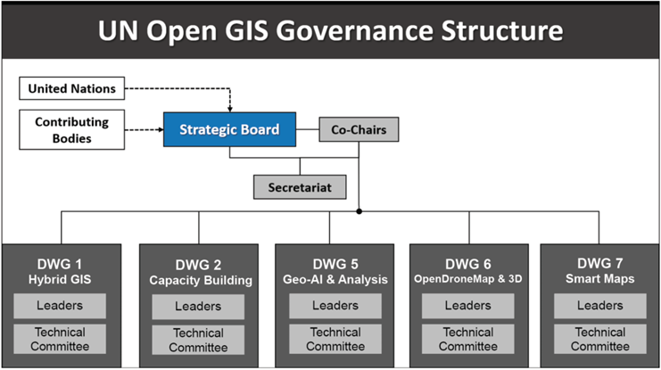
Governance Structure of UN Open GIS Initiative|Providing free open source GIS software for UN operations

Governance Structure

The UN Open GIS Initiative's governance structure comprises a Strategic Board, Co-Chairs, a Secretariat, and Domain Working Groups organized as follows:The Founders The UN Open GIS Initiative was founded through a collaborative effort, bringing together open-source GIS experts from various countries, organizations, and academic institutions to leverage open-source GIS technology in support of UN operations:§   Austria: Institute for Military Geography§   Germany:…MOREMORE 화살표